Skip to content Skip to footer
Town Hall, 333 Bay Street, Port Melbourne

Benjamin Bolton, Cash and Family Grocer

by David Thompson 
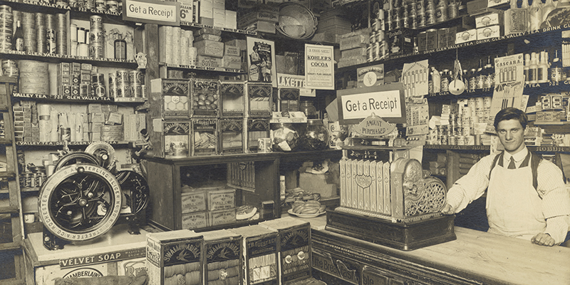
Interior, Benjamin Bolton, Family Grocer, Port Melbourne. c1913-c1916. Photographer Algernon Darge. State Library of Victoria. If you have visited Coles supermarket, in Bay Street, via the travellator leading from the rooftop car park, you will be familiar with this photograph. Taken by Algernon Darge around 1913-16, it shows the interior of Benjamin Bolton's Grocery store. It is held…

Read more

Cumberland Road

by David F Radcliffe Cumberland Road is one of a pair of curved streets that form the ‘entrance’ to the Fishermans Bend Estate. The other is Batman Road. Both run off “The Boulevard”, the bayside boundary of this estate conceived in the late 1930s to provide decent housing for working people. Both streets allude to the early European history of…

Read more

Streets and Reserves of the Fishermans Bend Estate

by David F Radcliffe During the preliminary phases of the Fishermans Bend Estate development, the Housing Commission of Victoria intended to name the streets numerically, i.e, First Street, Second Street, First Avenue, Second Avenue and so forth. Later their thinking changed…. Fishermans Bend was a pioneering project for the Commission which was established in March 1938 in response to the…

Read more

Mitchell Crescent

by David Thompson Mitchell Crescent is a private street that runs through the public housing estate between Nott Street and Bay Street curving towards Rouse Street at the back of the Exchange Hotel. The large block on the western side of Bay Street between Rouse Street and the beach served as the cable tram depot from 1890 until the tramway…

Read more

Johnston Street

by David F. Radcliffe Johnston Street runs from Graham Street to Beaconsfield Parade, one block back from Pickles Street. It was gazetted in 1865 along with many other streets on the eastern side of Sandridge Lagoon: Rouse Street East, Graham Street East, Liardet Street East, Esplanade East and Pickles Street. This was before any bridges crossed this dominant water feature.…

Read more

Melville (aka Malvery) Street

by David F Radcliffe Melville is a difficult-to-find street near the Port Melbourne Tennis Club; blink and you miss it. When the Crown Land south of Graham Street between Ross and Clark was surveyed and sold between 1868 and 1869, Albert Street was the only internal access road.[i] Melville was created as a private right-of-way in the late 1870s when…

Read more

PMHPS acknowledges the generous support of the City of Port Phillip.


The content of this site (images and text) must not be reproduced in any form without the prior consent of PMHPS or the copyright holder.

Acknowledgement of Traditional Custodians

We respectfully acknowledge the Traditional Custodians of the land on which we meet and work, the Bunurong Boon Wurrung and Wurundjeri Woi Wurrung peoples of the Eastern Kulin Nation and pay respect to their Elders past, present and emerging.