
Streets and Reserves of the Fishermans Bend Estate
by David F Radcliffe
During the preliminary phases of the Fishermans Bend Estate development, the Housing Commission of Victoria intended to name the streets numerically, i.e, First Street, Second Street, First Avenue, Second Avenue and so forth. Later their thinking changed….
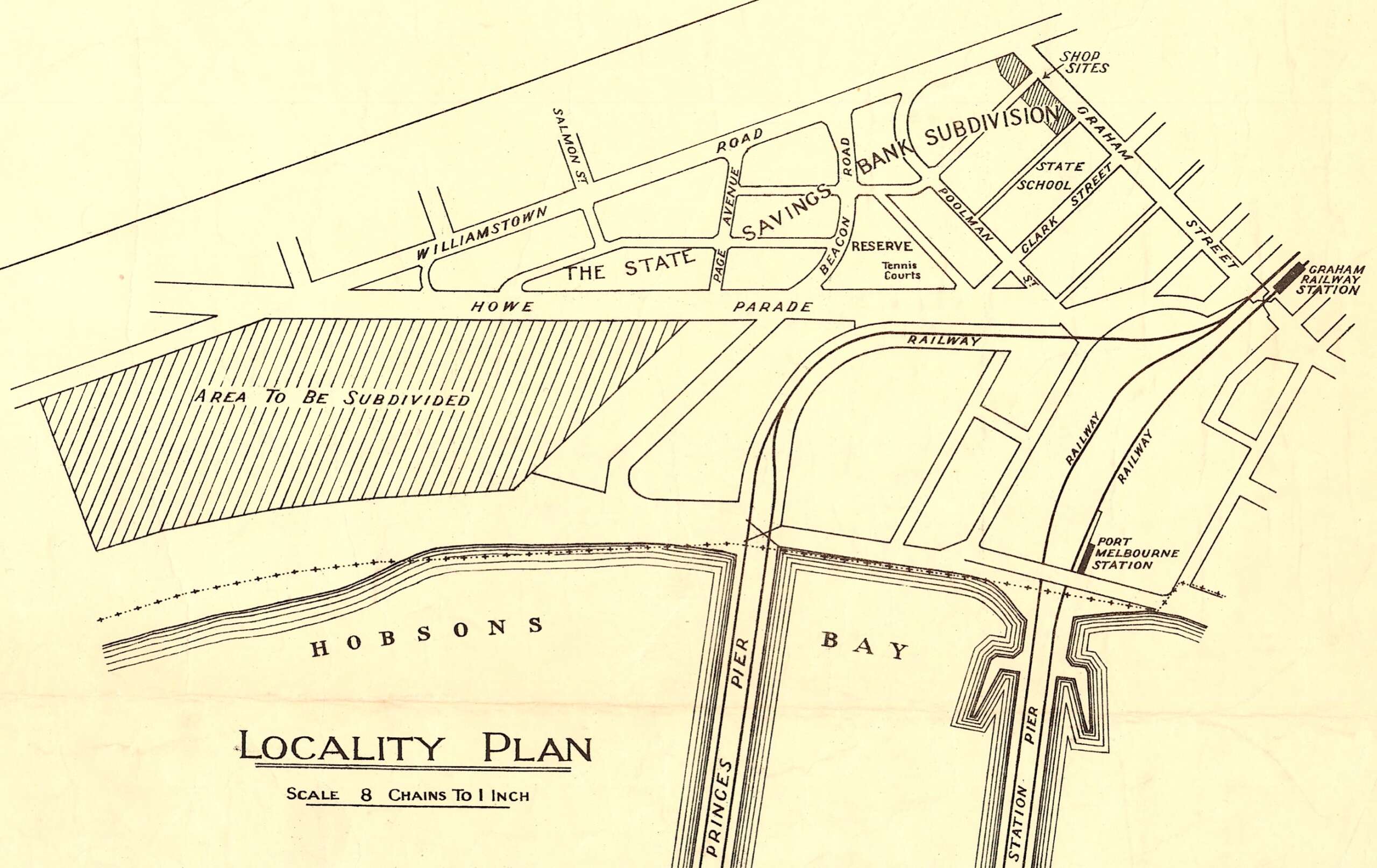
Fishermans Bend was a pioneering project for the Commission which was established in March 1938 in response to the report of the Housing Investigation and Slum Abolition Board tabled in the previous October.[i] This Estate was created to rehouse families from Port Melbourne and South Melbourne who were displaced from condemned houses. The area chosen was west of Princes Pier and south of the State Saving Bank housing subdivision, shown below.
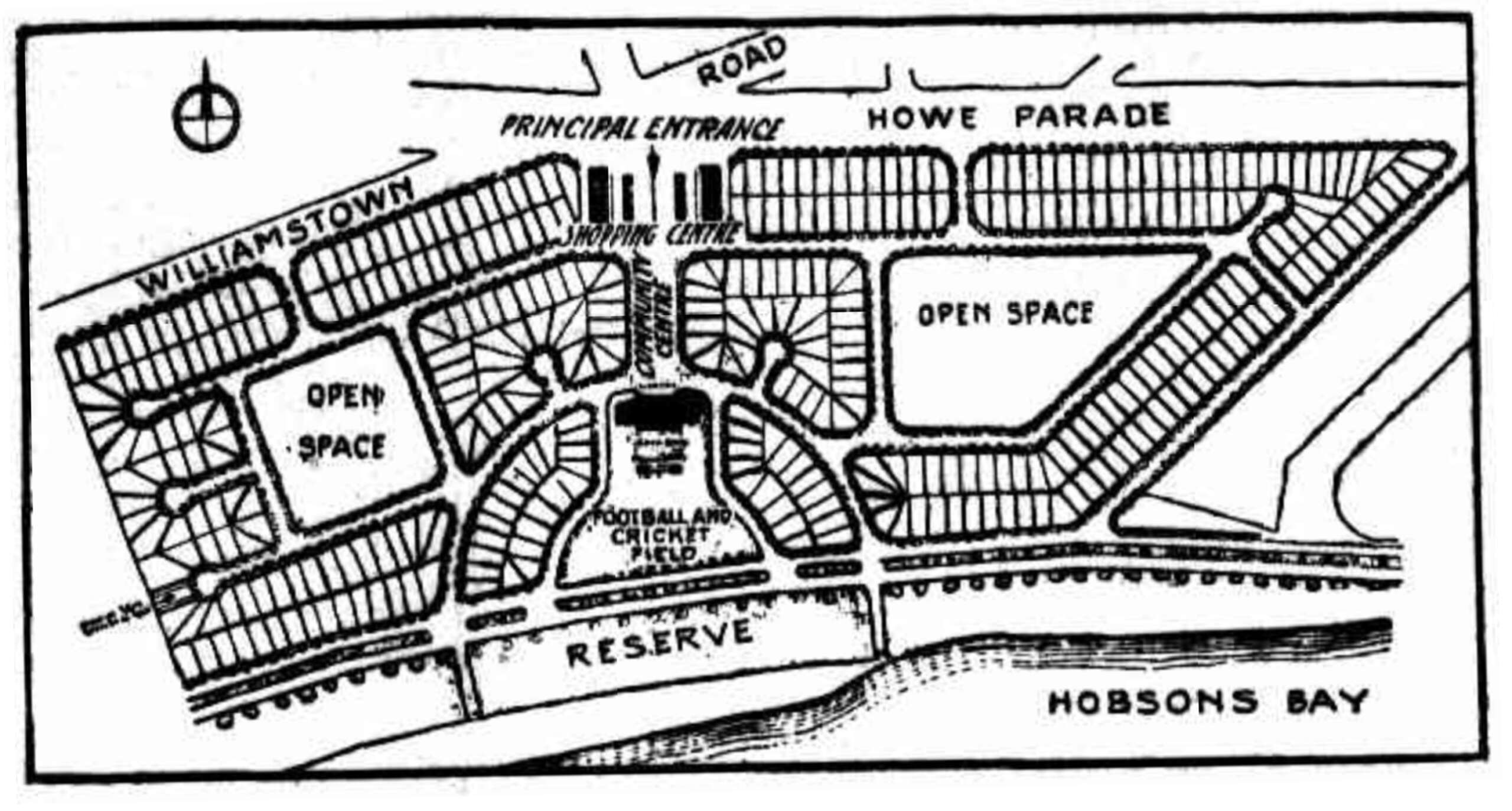
In February 1939, the Commission sought submissions for the layout of the estate and the design of the houses. The layout proposed by surveying firm Tuxen & Miller was selected.[ii] Saxil Tuxen’s extensive knowledge of modern town planning in America and Britain is reflected in the provision of the community centre with cul-de-sacs to minimise through traffic and housing lots located around three open spaces, west, central and east. [iii]
As this was a landmark project, the Housing Commission had second thoughts on their proposed street naming schema. They sought advice from A.S. Kenyon of the (Royal) Historical Society of Victoria on possible names that might best reflect the settled history of the area. They arrived at an eclectic mix of names for the internal roadways based on geography, settlement, leisure activities and maritime heritage.
Sandridge Avenue and The Bend reflect historic place names given by settlers to this area while Centre Avenue highlights the physical symmetry of the estate’s layout. The role of the Port Phillip Association is recognised in Batman Road, Gellibrand Road and Enterprise Avenue, the latter named after John Fawkner’s ship. The grand old paddle steamers that transported thousands of day trippers around Port Phillip Bay, the Hygeia, Ozone and Weeroona, were all remembered. Three other streets were named after vessels with local significance: Cumberland Road, Edina Avenue and Rosny Street.
As might have been expected, a nod was given to three contemporary politicians. Dunstan Parade was named after Albert Dunstan, State Premier (1935-1945).[iv] Pye Street honours Henry Pye, MLC (1932-1942), who chaired the Housing Investigation and Slum Abolition Board.[v] Albert Lind (Lind Avenue) was the Commissioner of Crown Lands and Survey (1935-1942), and Deputy Premier.[vi]
Two new roads formed the southern and eastern boundaries of the Estate, the Boulevard and Barak Road respectively. Newspaper reports announcing the names of the streets in the estate in 1940 did not mention Barak Road.[vii]
The aerial photo below shows the Fishermans Bend estate after completion. The area shaded in pink (lower right) shows some of the remaining shacks and houses of the fisher folk who had lived along the beach for many decades.
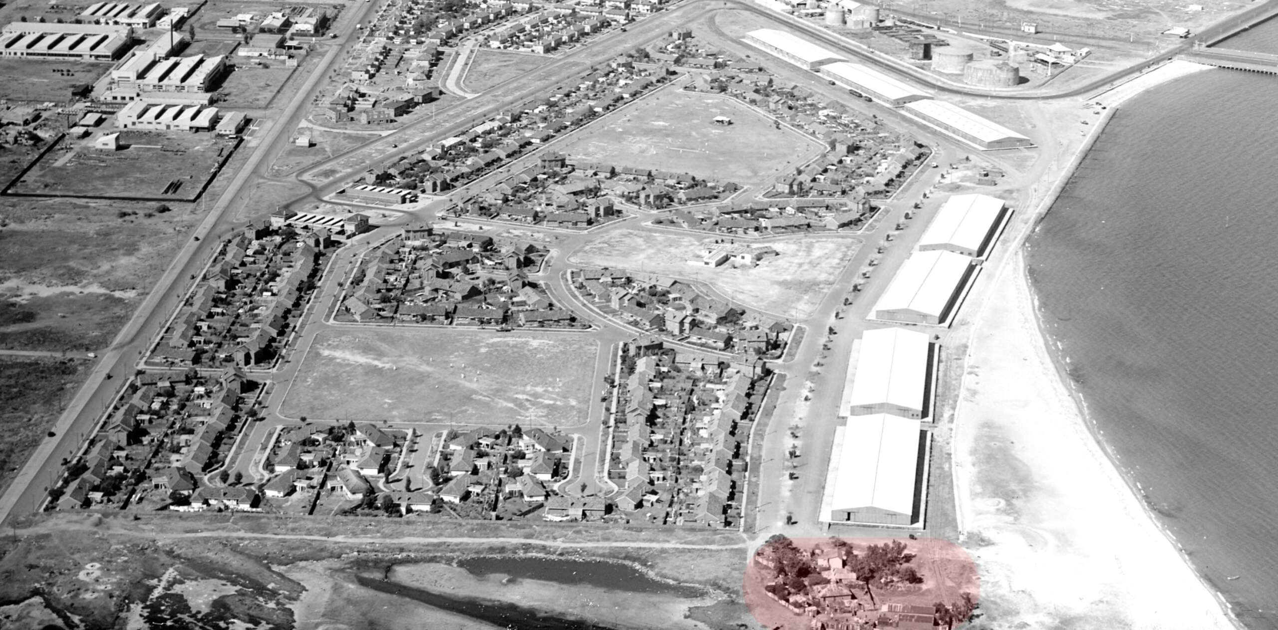
The open space on the western (near) side of the estate was later named the Buckingham Reserve and the eastern (far) one, the R.F Fulier Reserve. On the plan published in the 1939, the central open space was envisaged as a football / cricket field. Instead, it became the site for the Ada Mary A’Beckett Free Kindergarten and Infant Welfare Centre, as seen in the photo above.
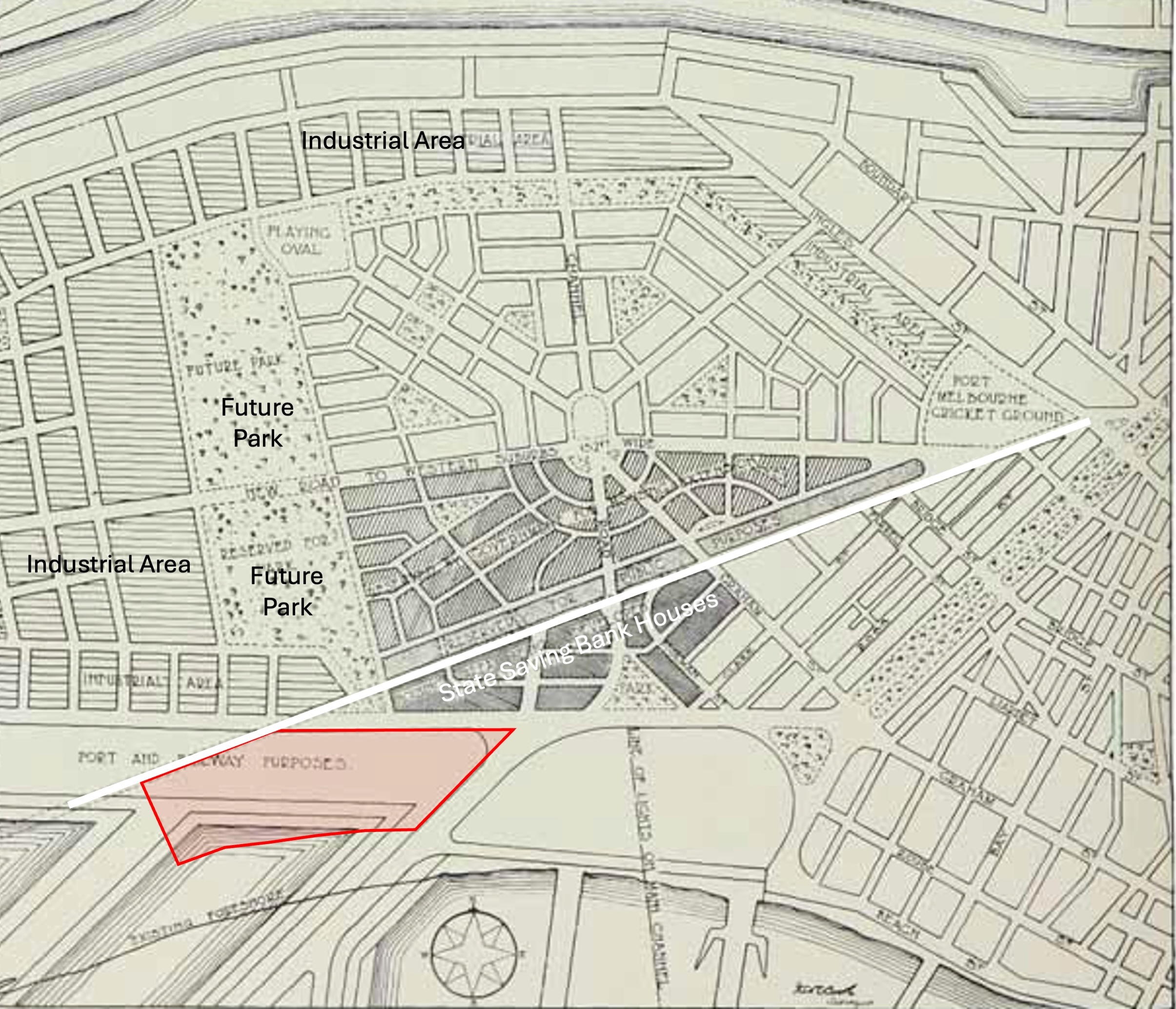
However, had the grand plans of the Metropolitan Town Planning Commission in 1929 come to fruition, this scene would have been very different. They envisaged an enormous extension of the State Bank House style subdivision on the north side of Williamstown Road (white line) surrounded by parkland, with industry along the Yarra as shown below. Docks (rather than more piers) were proposed along the bay immediately west of Princes Pier. To give a sense of scale, the footprint of the Housing Commission’s Estate (pink) is superimposed on the 1929 plan for Fishermans Bend. The Stock Market crash and the Great Depression put an end to this ambitious plan.
This was not the first “grand plan” proposing for docks and related infrastructure encompassing Fishermans Bend west of the Town of Sandridge (Port Melbourne) through to the Yarra. Many schemes were put forward from the 1850s to the 1880s, but these flights of fancy evaporated when the Coode Canal and Victoria Dock were built.
Yet in a strange twist, elements of the 1929 dock plan have now materialised, a little further west, as Webb Dock, which dominates the view from the Boulevard along the Fishermans Bend Estate. As working families began to move into their comfortable new homes in the Estate in the early 1940s, they could not have imagined the transformative impact that containerisation and automation was to have on the world of hard manual work they knew and employment patterns.
[i] 1938 ‘COMMISSION MEETS’, The Argus (Melbourne, Vic. : 1848 – 1957), 2 March, p. 2. , viewed 03 Apr 2025, http://nla.gov.au/nla.news-article11167395
[ii] David Nichols, ‘Tuxen, Saxil (1885–1975)’, Australian Dictionary of Biography, National Centre of Biography, Australian National University, https://adb.anu.edu.au/biography/tuxen-saxil-14890/text26079 , published first in hardcopy 2012, accessed online 2 April 2025.
[iii] 1939 ‘PLAN FOR 370 HOUSES AT FISHERMAN’S BEND’, The Age (Melbourne, Vic. : 1854 – 1954), 24 June, p. 33. (THE AGE LITERARY SUPPLEMENT), viewed 02 Apr 2025, http://nla.gov.au/nla.news-article205638136
[iv] J. B. Paul, ‘Dunstan, Sir Albert Arthur (1882–1950)’, Australian Dictionary of Biography, National Centre of Biography, Australian National University, https://adb.anu.edu.au/biography/dunstan-sir-albert-arthur-6055/text10357 , published first in hardcopy 1981, accessed online 2 April 2025.
[v] 1936 ‘REBUILDING IN MELBOURNE’, The Argus (Melbourne, Vic. : 1848 – 1957), 17 September, p. 13. , viewed 02 Apr 2025, http://nla.gov.au/nla.news-article11915861
[vii] J. D. Adams, ‘Lind, Sir Albert Eli (1878–1964)’, Australian Dictionary of Biography, National Centre of Biography, Australian National University, https://adb.anu.edu.au/biography/lind-sir-albert-eli-7198/text12449 , published first in hardcopy 1986, accessed online 2 April 2025.
[vii] 1940 ‘BY THEIR STREETS SHALL YE KNOW THEM’, The Argus (Melbourne, Vic. : 1848 – 1957), 19 February, p. 6. , viewed 03 Apr 2025, http://nla.gov.au/nla.news-article11285328; 1940 ‘MINISTERS AND SHIPS’, The Age (Melbourne, Vic. : 1854 – 1954), 19 February, p. 8. , viewed 03 Apr 2025, http://nla.gov.au/nla.news-article204012281
6 Comments
Deb Fisher
A fascinating article , how wonderful it would have been had the full scope of the project to the north of williamstown road been realized! thanks David
Robyn Watters
Truly excellent article David. Thank you.
David Radcliffe
Thanks Robyn. Pleased to hear you enjoyed it.
David Radcliffe
Glad you enjoyed the article, Deb. It will be interesting to see how the vision for the Wirraway Precinct of the FB Redevelopment, the area north of Williamstown Rd, turns out. David
Ruth Taylor
Thank you. II first came to Port Melbourne in 1966 on the Fairstar. I returned in 2009, to live here. I love Port, and am very interested in the history of the area.
David Thompson
Thanks Ruth.
The Society has meetings on the fourth Tuesday of the month at 7.30pm at Port Melbourne Town Hall, a monthly Newsletter and regular eBulletins for members, a working group on Tuesdays plus regular stories on the website.