Melville (aka Malvery) Street
by David F Radcliffe
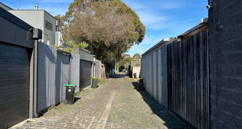
Melville is a difficult-to-find street near the Port Melbourne Tennis Club; blink and you miss it.
When the Crown Land south of Graham Street between Ross and Clark was surveyed and sold between 1868 and 1869, Albert Street was the only internal access road.[i] Melville was created as a private right-of-way in the late 1870s when the large Crown allotments (one half to one acre) between Albert and Ross Streets were subdivided. These much smaller building lots, typically 6 perches (1600m2), were marketed to “mechanics, workingmen, stevedores, lumpers, boatmen, mariners, widows, grocers, builders, speculators and others”.[ii]
For over 30 years, there was confusion about the name of this modest roadway. Was it Melville Street or Malvery Street? Between 1879 and 1911, these alternative names appeared in real estate advertisements and newspaper stories.[iii] For example, when the Council instructed its surveyor to prepare plans and specifications to seal and drain this right-of-way in 1888 it was called Malvery Street.[iv] A couple of years later it was referred to in Council discussions as Melville Street.[v] On one occasion it was reported as “Melville or Malvery Street” suggesting the name was somewhat contested.[vi]
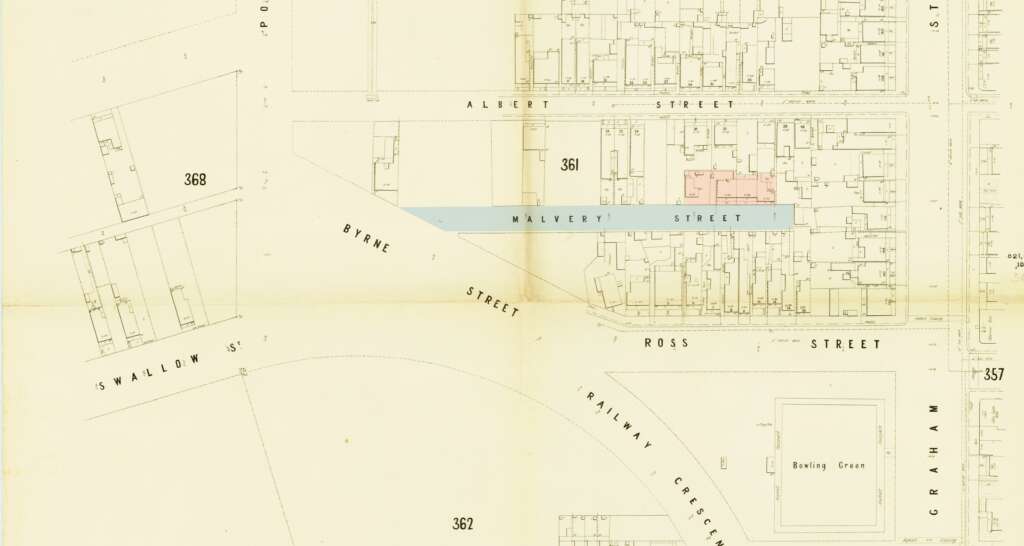
This uncertainty over the name is reflected in maps of the time. That highly reliable “go-to” resource for local historians, the MMBW map, lists the street as Malvery in 1894. Four small cottages are shown (in pink) near the northern end of this right-of-way.
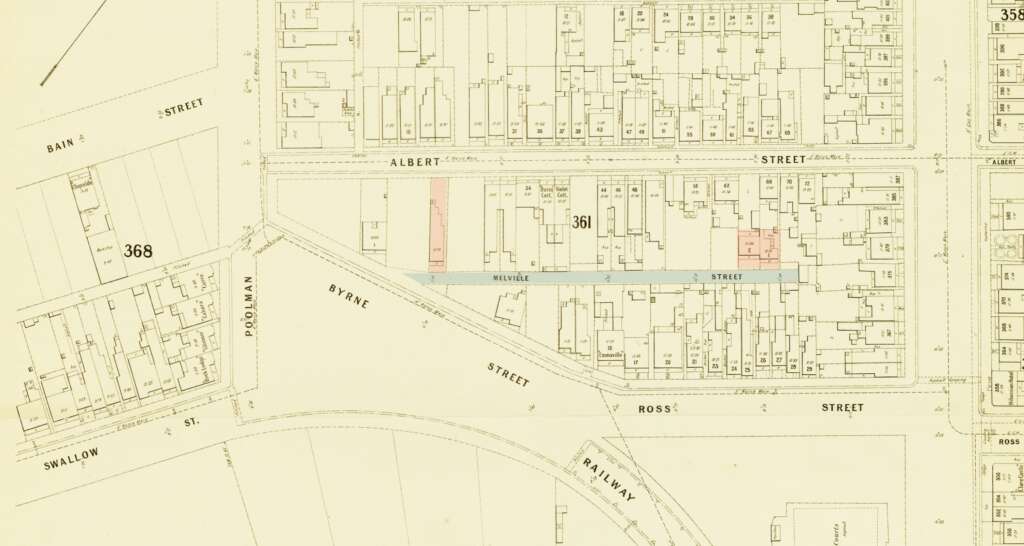
However, the 1911 MMBW map names this roadway Melville Street. By then, there were fewer houses deep into the street and one new dwelling near its junction with Byrne Street. This new build was hailed as a sign of “material prosperity” as the Borough climbed out of a prolonged economic downturn following the 1880s boom.[vii]
Meanwhile, health concerns were raised over stagnant water collecting in Melville.[viii] Due to the depressed economy, getting it sealed and properly drained dragged out over a decade. While the surveying of Melville (or Malvery) Street was first discussed in 1888, it was not until mid-1899 that the final plans and specifications were approved.[ix] Frustratingly, the work was not released for tender for another year.[x] Complaints about the “disgraceful state” of this unpaved laneway continued.[xi]
There was also the question of whether Melville Street should become a lane. In 1898, residents petitioned the Council to reduce its width from 31ft to 15ft with the 8ft gained on either side becoming part of the properties that abutted Melville. Questions about the implications of such a change on land titles were raised but seemingly not followed through.[xii]
As with other back lanes, the cottages deep in Melville Street were small and sometimes overcrowded. In 1900, the acting Health Officer reported to the Council that a cottage with just two rooms, one 9ft x 10ft and the other 9ft x 8ft housed two families. A couple lived in one room while the other was home to a man, his wife and their two children. The Health Officer recommended that only one family occupy the “house”.[xiii] By the 1940s, all the small cottages had disappeared from Melville.
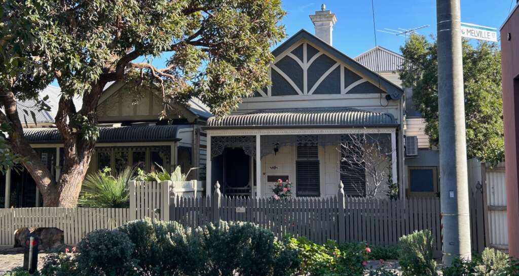
Only two houses remain on the street, both near the junction with Byrne Street. Next to these are another two houses which for many decades were listed as being on Melville but now have a Byrne Street address.
The origin of the names of this street or lane, Melville and Malvery, remains unknown. Many informally named rights-of-way in Port Melbourne are associated with people who lived in or developed them, e.g. Barlow and Drysdale Streets, Turville Place and Brewster’s Lane. However, there does not seem to be anyone named Melville or Malvery with a definitive link to property in or near this right-of-way. Indeed, the name Malvery does not appear in historical directories or the Victorian Registry of Births, Deaths, and Marriages. Perhaps it was Malvern or Mulvaney misspelt.
[i] Originally the land between Graham and Bismarck (later Poolman) and Ross and Clarke Streets had no Section number. Later it was designated 3A.
[ii] 1879 ‘Advertising’, The Record and Emerald Hill and Sandridge Advertiser (Vic. : 1872 – 1881), 31 October, p. 2. , viewed 31 Aug 2024, http://nla.gov.au/nla.news-article108501731
[iii] The last newspaper reference to Malvery Street. 1911 ‘Advertising’, Standard (Port Melbourne, Vic. : 1884 – 1914), 14 October, p. 2. , viewed 01 Sep 2024, http://nla.gov.au/nla.news-article165164159
[iv] 1888 ‘LOCAL BOARD OF HEALTH.’, Standard (Port Melbourne, Vic. : 1884 – 1914), 24 March, p. 2. , viewed 31 Aug 2024,http://nla.gov.au/nla.news-article164933604.
[v] 1891 ‘PORT MELBOURNE BOROUGH COUNCIL’, Standard (Port Melbourne, Vic. : 1884 – 1914), 24 October, p. 3. , viewed 01 Sep 2024, http://nla.gov.au/nla.news-article164429094
[vi] 1891 ‘PORT MELBOURNE BOROUGH COUNCIL.’, Standard (Port Melbourne, Vic. : 1884 – 1914), 21 November, p. 3. , viewed 01 Sep 2024, http://nla.gov.au/nla.news-article164431561
[vii] 1909 ‘New Buildings.’, Standard (Port Melbourne, Vic. : 1884 – 1914), 13 March, p. 2. , viewed 31 Aug 2024, http://nla.gov.au/nla.news-article164954642.
[viii] 1890 ‘PORT MELBOURNE POLICE COURT.’, Standard (Port Melbourne, Vic. : 1884 – 1914), 3 May, p. 3. , viewed 31 Aug 2024, http://nla.gov.au/nla.news-article164424082.
[ix] 1899 ‘PORT MELBOURNE COUNCIL’, Record (Emerald Hill, Vic. : 1881 – 1954), 20 May, p. 2. , viewed 31 Aug 2024, http://nla.gov.au/nla.news-article108490495
[x] 1900 ‘Advertising’, Standard (Port Melbourne, Vic. : 1884 – 1914), 16 June, p. 2. , viewed 31 Aug 2024, http://nla.gov.au/nla.news-article164945200.
[xi] 1899 ‘CORRESPONDENCE’, Standard (Port Melbourne, Vic. : 1884 – 1914), 16 September, p. 4. , viewed 31 Aug 2024, http://nla.gov.au/nla.news-article165314659.
[xii] 1898 ‘STREET OR LANE.’, Standard (Port Melbourne, Vic. : 1884 – 1914), 13 August, p. 3. , viewed 31 Aug 2024, http://nla.gov.au/nla.news-article165315769
[xiii] 1900 ‘Items of Hems.’, Standard (Port Melbourne, Vic. : 1884 – 1914), 22 September, p. 2. , viewed 01 Sep 2024, http://nla.gov.au/nla.news-article164948136
