Brewster’s Lane
by David F Radcliffe
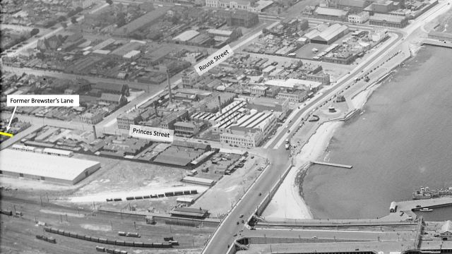
Brewster’s Lane disappeared from Port Melbourne twice. First, it was erased from local memory after the name of this small roadway changed in 1889. A century later, all traces of the laneway were lost when the area was redeveloped. The aerial photograph below shows the location of the former Brewster’s Lane.
The trebling of Victoria’s population during the early years of the gold rush transformed Sandridge. In 1849, it comprised six Sections (city blocks) bounded by the beach in the south, Graham Street in the north, Stokes Street in the west and the Lagoon in the east, as indicated by the dotted line on the image below. By the mid-1850s, thirty-two Sections had been designated, some sub-divided and sold while others were still swamp. The construction of the Melbourne to Hobson’s Bay Railway in 1854 impeded westward expansion just as the Lagoon did to the east, causing the township to grow northwards.
Because the railway was not parallel to the existing north-south streets (e.g. Bay Street), some of these new Sections were oddly shaped. One such was Section 15, bounded by Railway Place (later renamed Princes Street), Graham Street near the rail crossing, Station Place (later renamed Station Street) and Clifford Street. An internal laneway running the length of the Section was included to provide rear access for night carts to future houses on Station Place and Railway Place.
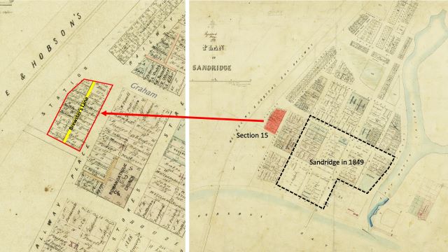
The Crown allotments in Section 15 were auctioned in June 1856. George Frederick Brewster purchased the one on the northwest corner with frontages onto Graham Street and Station Place. He built a cottage on the block where he and his wife, Elizabeth Thomasina James, raised their family. George and Elizabeth were both from London and were living in Sandridge when they married two years earlier at St Paul’s Church in the city.[1] George, aged 31, worked as a customs officer. Elizabeth was 28. George changed occupation, in 1863, becoming the local agent for the Australasian Insurance Company.[2]
In 1868, George sold his cottage and land in Section 15. By now, the access roadway that ran through it was known as Brewster’s Lane.[3] Reflecting the timeless real estate adage – ‘location, location, location’ – the advertisement highlighted the commanding position of the property near the railway crossing and hence its potential as the site of a future business given the growing population and a proposed new road to St Kilda (see image below). But rather than exploit this potential, Brewster moved to Beach Street, between Railway Place and Stokes Street where he operated a tobacconist and grocery shop for the next decade. He also continued to act as an insurance agent, now for the Queen Insurance Company. In this capacity, George testified in a case of suspected arson and insurance fraud.[4] In the early 1880s, the Brewster family moved away, initially to South Yarra and then Albert Park.
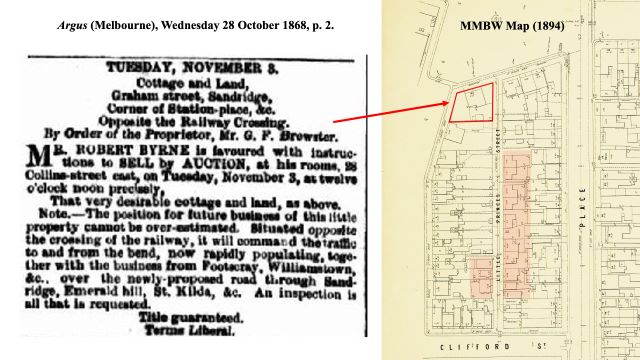
As happened frequently when new Crown land was released, most of the original sixteen building allotments in Section 15 were subdivided and resold. Consequently, the density of houses was much higher than originally planned. This included thirteen small dwellings constructed on Brewster’s Lane, indicated by the shaded area in the image above. Priscilla and Frederick Peterson, later of Ross Street lived in one of these small houses in the early 1870s. Unfortunately, Brewster’s Lane developed an unsavoury reputation. The ‘shocking murder’ of Jane Vann there in 1881 reinforced these negative perceptions. The sordid details of this case were reproduced in newspapers around the country.[5]
So, in December 1889 the residents of the lane petitioned the Port Melbourne Council to change the name to the much more salubrious Little Princes Street.[6] The name Brewster’s Lane faded from memory. Over the next thirty years, the number of houses on this narrow roadway declined to just three. By 1950, there was no one living in Little Princes Street.
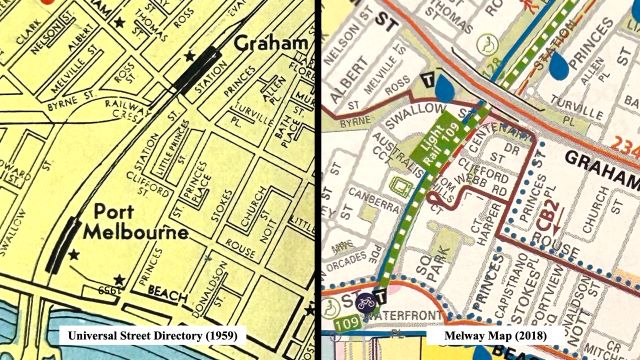
In the second half of the 20th Century, two redevelopment cycles reshaped Section 15. Little Princes Street (Brewster’s Lane) disappeared off the map when the mid-rise Housing Commission flats were built there in the 1960s. Townhouses replaced these flats in the early 1990s, resulting in a new configuration of internal streets on what had been Section 15. To confuse matters, one of the new streets, Clifford Street, runs parallel to the original street of the same name but is located further north. See the images above.
What then of George and Elizabeth Brewster? Beyond being a customs officer, an insurance agent, and running a small grocery business, George was a supporter of the Botanical Gardens.[7] His horticultural interests extended to extolling the virtues of the tree-mallow as an abundant, nutritious, and wholesome food for livestock.[8] Unusual for the era, the family home in Albert Park was owned by Elizabeth, not George.[9] She passed away in 1889, leaving the property to her two unmarried daughters on the condition that they provide a home for their father (George) and their younger brother.[10] George passed in 1908.
[1] In 1854, St Pauls was then just a church. It was demolished and the Cathedral built in the 1880s
[2] 1863 ‘Advertising’, The Age (Melbourne, Vic. : 1854 – 1954), 4 September, p. 7. , viewed 09 May 2024, http://nla.gov.au/nla.news-article154965183
[3] 1868 ‘Advertising’, The Argus (Melbourne, Vic. : 1848 – 1957), 28 October, p. 2. , viewed 09 May 2024, http://nla.gov.au/nla.news-article5830998
[4] 1875 ‘Serious Charge of Arson at Sandridge’, The Record and Emerald Hill and Sandridge Advertiser (Vic. : 1872 – 1881), 10 September, p. 3. , viewed 10 May 2024, http://nla.gov.au/nla.news-article108498930
[5] 1881 ‘Shocking Murder at Sandridge’, Leader (Melbourne, Vic. : 1862 – 1918, 1935), 10 December, p. 21. , viewed 09 May 2024, http://nla.gov.au/nla.news-article198493669
[6] 1889 ‘Port Melbourne Borough Council’, Standard (Port Melbourne, Vic. : 1884 – 1914), 14 December, p. 3. , viewed 09 May 2024, http://nla.gov.au/nla.news-article164428654
[7] 1863 ‘The Botanical Garden’, The Argus (Melbourne, Vic. : 1848 – 1957), 26 May, p. 7. , viewed 09 May 2024, http://nla.gov.au/nla.news-article6486055
[8] “Weekly Agricultural Report.” The Ballarat Star (Vic. : 1865 – 1924) 12 January 1866: 4. Web. 9 May 2024 http://nla.gov.au/nla.news-article112866466
[9] The Married Women’s Property Act of 1884 (Victoria) granted married women the same rights as single women to acquire, hold and dispose of real and personal property.
[10] Elisabeth Thomasina Brewster, Will (1885), Public Record Office Victoria.