Fishermans Bend – do the maps
On Sunday 7 July, several members of the Society attended a forum on the Future of Fishermans Bend convened by the Community Alliance of Port Phillip. To follow this discussion into the future, it is probably necessary to become familiar with the acronym FBURA for Fishermans Bend Urban Renewal Area.
Background
On 5 July 2012, the Minister for Planning rezoned a large area of Fishermans Bend to the Capital City Zone. At 240 ha, the FBURA is bigger than Docklands and Southbank combined. It is the largest urban renewal project in Australia. The rezoning was made without a planning framework of any kind being in place which has led to a rash of speculative development proposals.
Getting clear on Fishermans Bend
To a Port Melbourne person, Fishermans Bend has a particular meaning. It is often locally referred to as ‘The Bend’. But since we are entering a period of public debate, a definition can be useful. Allan Meiers, in his book Fisherfolk of Fishermans Bend offers this definition: “Fishermans Bend: A term used by Sandridge Council to designate all the land bounded by the seashore at Hobsons Bay, the northermost bend of the Yarra River and Boundary St which divides South Melbourne and Port Melbourne”.
This is well illustrated in the following 1914 map:
 |
| Port Melbourne, Parish of South Melbourne, County of Bourke 1914 State Library of Victoria |
All the land shown on the above map was part of the City of Port Melbourne until shortly prior to the amalgamation of local councils in 1994 – including the northern bump around Coode Island.
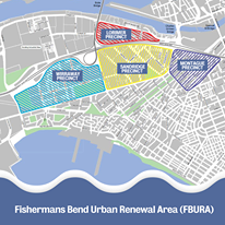
The boundaries of the Fishermans Bend Urban Renewal Area are shown in the coloured hatched sections of the map below. As you can see, it is not the same as the area as conventionally and historically understood to be Fishermans Bend.
Hope this sheds some light on the matter of Fishermans Bend.
Sources and further information
Allan Meiers Fisherfolk of Fishermans Bend piv
State Library of Victoria Port Melbourne, Parish of South Melbourne, County of Bourke 1914
